So my NW2SE hike didn’t quite pan out as planned but the name still fits. From the north west of Scotland to the south east of England didn’t happen, but turned out instead to be north west Scotland to south east Scotland. That’ll do.
These are what I consider to be the best pics along the way. All (unless stated) are taken on a Panasonic Lumix GF6 with a 14-42mm lens. Some of the quality is lost here because I’ve had to reduce the file size so it loads quicker but I’m pretty chuffed with the results.
If I’d have remembered to turn on the GPS function on the camera it would have helped me pinpoint where I actually took them, but I didn’t! So, I’ve been shifting back through my trail diary, the info of each photo, and trying to connect the dots. The first one is a little vague I’m afraid! I hope I have the locations all correct, but if you spot something that isn’t right, please feel free to let me know.
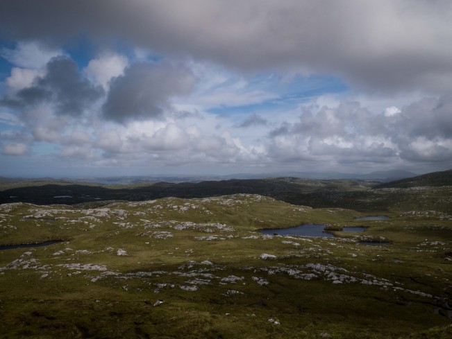
Somewhere near Ben Dreavie – Cape Wrath Trail
This is typical Cape Wrath Trail, as in there is no trail. I had to keep an eye on navigation all the time. With a visible trail it’s easy to keep track, but with nothing to focus on, and a landscape such as this, it wasn’t hard to get confused. As with most days in Scotland, the skies and cloud formations were stunning. The light paints a mesmeric landscape, softening any harsh edges. Early morning brings overcast skies but tempered with swirls, ripples and eddies as the light glances over.
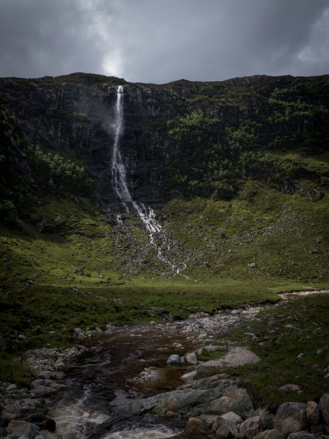
Eas a Chual Aluinn Waterfall – Cape Wrath Trail
Near Glencoul Bothy & Loch Beag. Couldn’t believe this when I saw it, sat down and watched, mesmerized for an hour. It’s 658 feet high! Three times the height of Niagra Falls and I’d never seen it, or indeed heard of it. Not surprising as it is out in the middle of nowhere. This wasn’t tourist territory with a car park and pub just down the road, it’s a slog to get there but as you can see, well worth the effort.

Peaks on the horizon are Sail Liath, Stob Cadha Gobhlach, Corrag Bhuidhe, An Teallach and Glas Mheall Liath – Cape Wrath Trail
Quite possibly my favourite photo of the entire trip. As I climbed up from Inverleal, before dropping down to a small cluster of houses at Corriehallie, this is what greeted me. I’d caught a glimpse of these peaks the day prior and wondered (more hoped) that I’d not only pass them, but experience them up close. A glorious view showing off Scotland at its best. Despite the section of trail being sandwiched between two roads, it could have been the middle of nowhere.

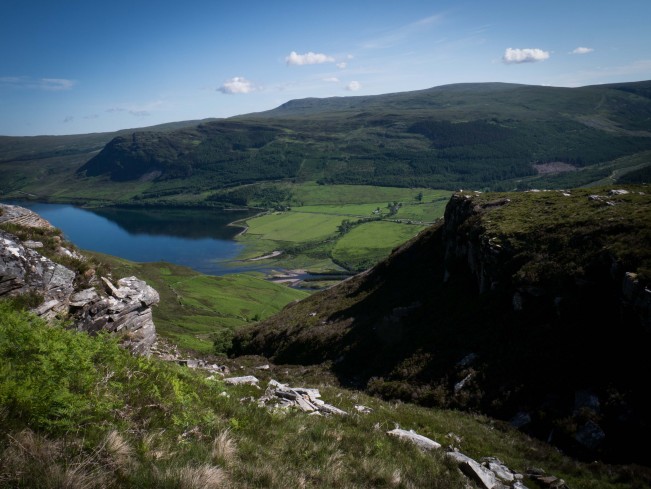
Loch Broom near Inverleal – Cape Wrath Trail
I wasn’t looking forward to the climb out of Inverleal but the reality was much easier than the prospect. I’d stared at the ascent the previous evening and much as I enjoy a decent climb, it looked steep. Sure enough, for half an hour I plodded, then the plod quickened, the legs warmed and reciprocated, and I was up and over. I had stayed down in the valley the previous night and it was a wonderful perspective to look back down on it.
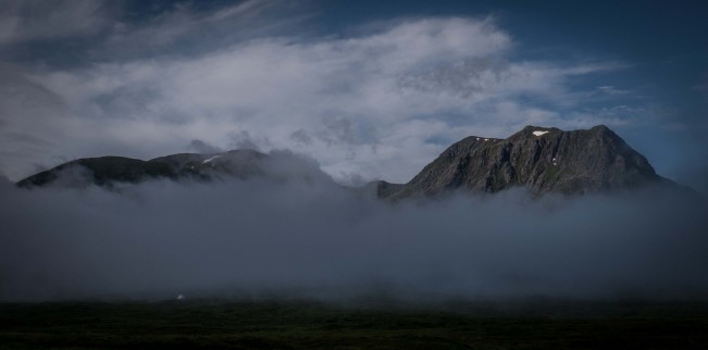
Glen Coe – West Highland Way
As an early morning mist slowly dispersed, Scotland undressed itself. I woke up to see this directly from my tent, it didn’t cost me anything to stay there, I had a comfortable night, ate well and enjoyed a cooling breeze through the tent mesh. Pay £100 for a hotel for the night or enjoy views like this for nothing.

On the shore of Lochan Fada – Cape Wrath Trail
Still bright at 21.30. My trekking pole snapped here so I had to sleep out. Despite forecast rain and the usual midges, it stayed dry all night and a stiff breeze saw of the insects. Undoubtedly the best night of the trip, amazing memories.
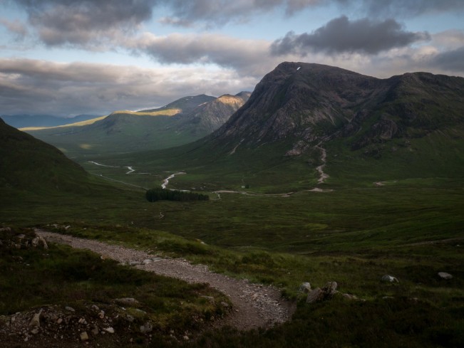
The Devils Staircase and Glen Coe – West Highland Way
End of day one on the West Highland Way, taken at 20.30 and still as bright as mid-day. The track descending down is known as the Devils Staircase. I wanted to camp at the top between the peaks of Stob Mhic Mhartuin and Beinn Bheag but the ground wasn’t forgiving enough. Descending I spotted tents just by the visible clump of trees but all the flat spots were taken so I carried on and camped near the road.

Solitary Tree – West Highland Way
This was actually taken on my smartphone and although the quality is half decent, I wish I had taken the time to capture it on the camera as well. Just after an ascent from the Inversnaid Hotel it caught my eye, as solitary trees often do. Something about them, don’t know exactly what but they always look great.


Glen Coe – West Highland Way
An hour after waking to a low slung mist, slowly it lifted and the views appeared. I’ve driven through Glen Coe on the A82 so many times, now it was time to hike through it. I expected magnificence and it bowed to my wishes, this is an epic part of Scotland. I slowed for most of the morning, trying to take it all in, making regular stops to sit on a warm rock. After hiking for 31 days, of which it rained at some point for 28 of those, I’m glad I had the perfect day to experience one of my favourite places.
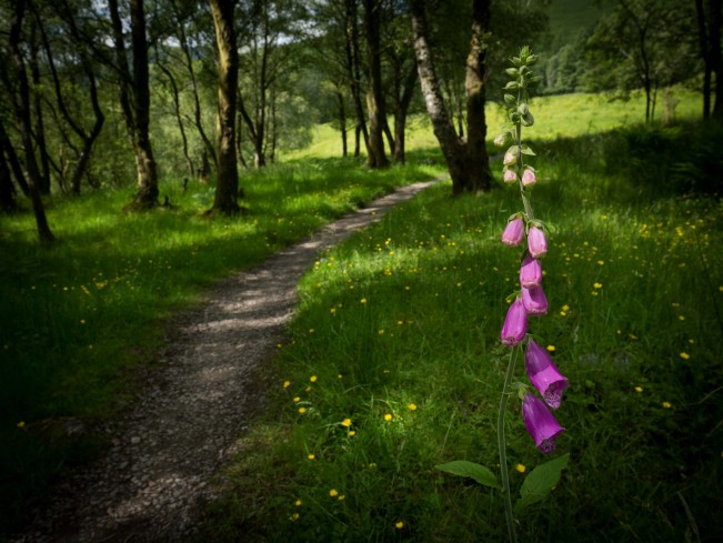
A solitary Foxglove – West Highland Way
Saw them everywhere but often just one on its own, advertising its presence by vibrant pink flowers.

Looking up towards Loch na Sealga.
I met two mountain bikers here who told me that the Shenavall Bothy was just down the track. Alas, it was only mid-morning so I veered left here, following the gushing waters of Amhain Loch an Nid. Loch an Nid itself appeared, complete with two fishermen on the southern banks. A waved greeting, followed by a brief chat (mainly in the hope of securing a fish for dinner which wasn’t forthcoming) saw me continue up, using the impressive summit of Beinn Bheag as a bearing. Veering south west I ended at Lochan Fada (see above) for my night under the stars.

Oykel Bridge – Cape Wrath Trail
Shortly followed by lunch and a pint at the Oykel Bridge Hotel.